
Ozark ZIP Code Coverage
The verified local entry is deliberately narrow. USPS confirms the Ozark Post Office and the postal ZIP 65721. Official research did not safely establish any additional ZIP as serving Ozark proper, and it did not produce a reliable list of every address that falls inside or outside the city under that postal label. A complete-looking list would overstate what the available official sources prove.
| ZIP | Areas Covered | Post Office | Notes |
|---|---|---|---|
| 65721 | Ozark postal city and addresses using the Ozark post office | Ozark Post Office, 1450 W. Jackson St., Ozark, MO 65721-9998 | USPS confirms the office and ZIP. Postal geography is not a city-limit determination, and the exact in-city and outside-limit extent was not located in official sources. |
Nearby postal locations mention Nixa 65714, Sparta 65753, Highlandville 65669, and Springfield 65804 in service context. Those are not counted here as Ozark-serving ZIPs. Run USPS city-and-state or address lookup first, then compare a returned address with the Christian County corporate-limit and town layers.
Ozark ZIP Code Search
The USPS lookup is the postal starting point for an Ozark ZIP code directory search. Its three available modes are finding a ZIP by street address, finding ZIP codes by city and state, and finding cities by ZIP. A returned match standardizes delivery information. It does not establish that a named person receives mail at the address, and it should not replace a parcel or jurisdiction check.
- Open the USPS ZIP lookup and choose the address, city-and-state, or ZIP-to-city mode that matches the information in hand.
- Enter the address as accurately as possible and preserve the returned postal city, state, ZIP, and ZIP+4 if USPS provides one.
- Compare the result with the Christian County parcel's situs city, parcel identifier, and corporate-limit or town layer. A postal city can differ from the governing jurisdiction.
- Use the matched address to inspect an official parcel or city record. Once the area narrows to one street, use the Ozark street directory process for the address and deed trail.
USPS is the verification path for delivery geography. It should remain the first check even when another local record displays a ZIP field.
Ozark ZIP Code Terms
Postal terms describe routing, not land ownership or municipal boundaries. Keeping the terms separate makes an Ozark ZIP code directory result easier to compare with assessor and GIS data.
- ZIP Code
- A postal routing code used by USPS to direct mail to a delivery area or post office.
- ZIP+4
- An added four-digit delivery-routing extension. It does not identify an individual occupant.
- PO-box ZIP
- A postal code used for post-office-box delivery. Research did not verify a separate Ozark PO-box-only ZIP.
- Unique ZIP
- A postal code assigned to a single large organization or destination. None was verified for Ozark in the inspected sources.
- Carrier route
- A USPS delivery grouping within a postal area, not a city-boundary line or resident list.
USPS ZIP Code Basics explains standardized addressing and the delivery purpose of ZIP and ZIP+4 information.
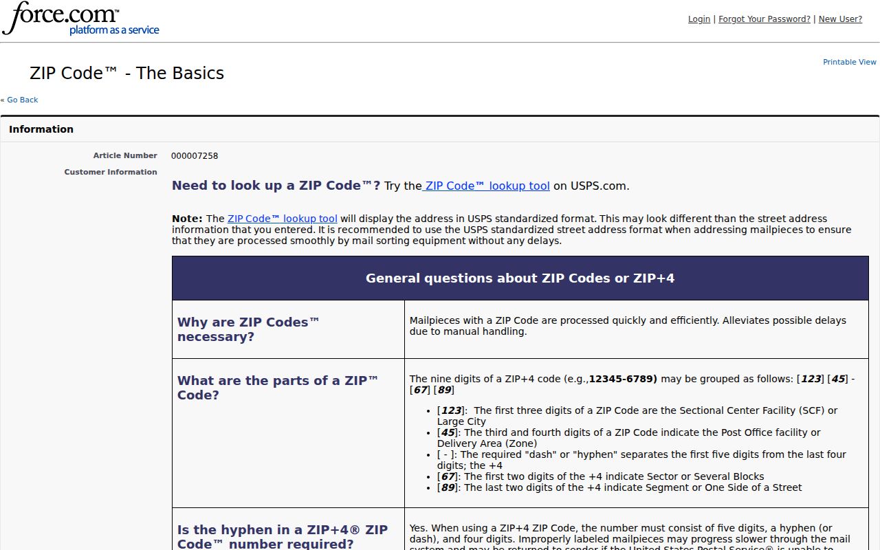
The postal explanation reinforces why a routing match should be recorded as a delivery result, then checked against a parcel's legal and municipal context.
Ozark ZIP Code GIS Fields
Christian County's GIS parcel service contains a ZIP field, but the service is a queryable feature source rather than a ready-made ZIP directory. The contractor assessor search may offer ZIP or property filters, yet the official text capture did not expose those interface controls. The table distinguishes what the research verifies from claims that should not be made.
| Field or search mode | Source | What is verified | What it does not establish |
|---|---|---|---|
| ZIP field | Christian County parcel GIS | Parcel data contains a ZIP attribute that can be queried in the map service. | An exposed assessor ZIP filter or a public directory of everyone receiving mail. |
| Situs street and city | Christian County parcel GIS | Parcel layers include situs street and city fields. | That an owner mailing address is the same as the parcel location. |
| Parcel ID and legal description | Assessor and GIS | Local parcel identifiers and legal-geography fields connect an address to land records. | Current residence or household membership. |
| Identify and query | Christian/Ozark map service | The service supports identify, query, pagination, ordering, JSON, GeoJSON, and advanced query operations. | A verified client-side ZIP browse button, buffer tool, or ZIP export control. |
| Address lookup | USPS | USPS offers address-to-ZIP, city-and-state, and ZIP-to-city modes. | Property ownership or city-limit status. |
When a GIS query returns features under one ZIP field, review each feature before treating it as a useful record. The result can include vacant land, common areas, commercial parcels, and parcels where the owner mailing address is elsewhere.
Ozark Postal Geography
Ozark's record geography includes postal ZIPs, city corporate limits, three city wards, Christian County parcels, town layers, and legal descriptions. These systems serve different purposes. The county GIS helps locate land and parcel attributes. The ward map supports civic geography. USPS describes delivery geography. None should be substituted for another simply because the city name appears in a label.
This is the page's central geography check: preserve the returned postal city and ZIP, then write down the parcel situs city and the city-limit or town-layer result separately. A postal city may be Ozark while a location falls outside the municipal boundary, and a nearby postal label can be geographically close without placing the parcel in a different county.
Note: The official sources did not provide an address-by-address list of Ozark ZIP and city-limit mismatches, so each address needs its own USPS and GIS comparison.
Ozark City Limit Check
Use the Christian/Ozark GIS map service after USPS returns a postal result. Locate the parcel or address point, then review the associated corporate-limit or town context. The parcel's legal description, subdivision, and section or township fields can be stronger continuity tools than a mailing-city label when a record trail reaches an older deed or plat.
Keep both labels. Record the USPS delivery city and ZIP beside the assessor situs city and city-limit result. A difference is a routing or jurisdiction question to resolve, not evidence that the record is wrong.
The city Planning Department handles development, zoning, and platting, while the county GIS and Assessor hold the county parcel map. For address-assignment authority or a documented readdressing policy, official research found a gap and recommends asking Christian County GIS or 911 and Ozark Planning directly.
Ozark Post Office Context
The USPS Ozark Post Office location record identifies the office at 1450 W. Jackson St., Ozark, MO 65721-9998. The researched listing gives retail hours of 8:30 to 4:30 Monday through Friday and 9:00 to 12:00 Saturday, plus phone 417-581-2754. Check the current USPS record before a visit because postal hours and service details can change.
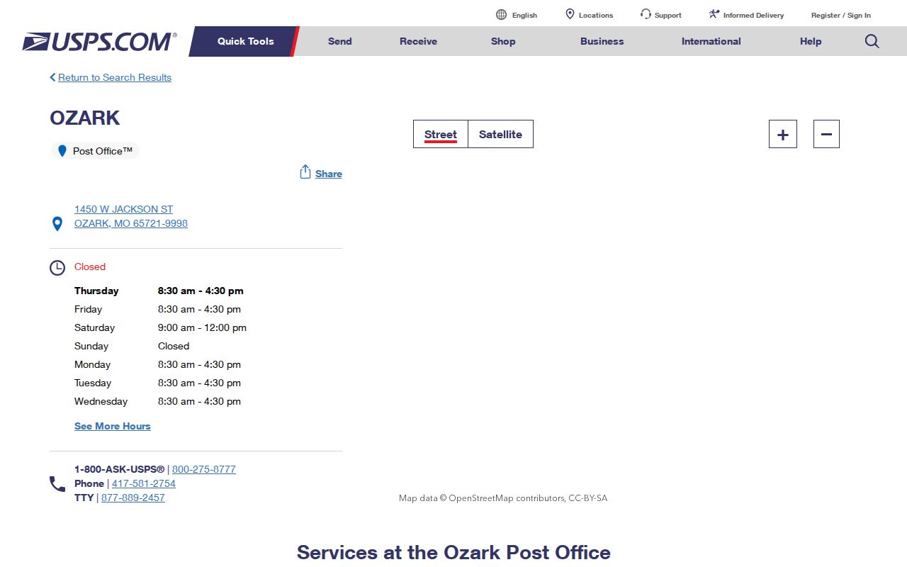
The office record confirms a post office and postal ZIP. It does not turn the post-office ZIP+4 context into a separate citywide ZIP or identify the person associated with an address.
Ozark ZIP Record Limits
A ZIP code cannot produce a public roster of every Ozark resident. Missouri's voter lookup requires a precise registered name, date of birth, last four Social Security digits, and county. Its research record does not identify a public ZIP-search mode. A voter-file request may have a different process, but the current Christian County request form, cost, and format were not located, so a ZIP page should not promise an extract.
The Missouri offender registry accepts ZIP as one statutory public-safety search option, but it has its own warnings and must not be merged with ordinary address results. City permits can be searched by address, dates, and type, not by a confirmed ZIP-wide public mode. Parcel, USPS, and city information should be used only for the limited record question each source can support.
A parcel feature can represent vacant land, a common area, a business parcel, or land whose owner's mailing address is elsewhere. Likewise, a postal result validates the route for an address, not a current resident or business connection. Record the source type before comparing names or addresses across the Ozark and Christian County records chain.
Ozark Historic Address Labels
For older Ozark records, pair a postal result with the Recorder legal description, plats, Sanborn maps, city archive notices, and any authenticated reverse directory. No official dated ZIP split or realignment for Ozark was located. No citywide street-renumbering year was verified either. Do not convert Census ZIP Code Tabulation Areas into USPS delivery boundaries, and do not explain an address mismatch with an unverified renumbering story.
Christian County's historical deed indexes, map layers, and archived city materials can bridge a changed label when the legal parcel remains identifiable. The key is to retain the date and source for every address label rather than treating a modern postal code as a permanent description of the place.
Ozark ZIP Search Results
A useful Ozark ZIP result should state whether it comes from USPS, a parcel field, a city archive, or another named custodian. Save the search date, the full standardized address, the returned postal label, the PID or legal description when applicable, and the city-limit result. This keeps delivery information from being confused with ownership, residence, or government jurisdiction.
The confirmed Ozark postal entry is 65721. Additional ZIP coverage remains a transparent research gap until USPS city-and-state results and county corporate-limit layers are reconciled for each returned address.
Use the ZIP as a first geographic filter, not the final answer. The county map service can return parcel features under a ZIP attribute, yet each feature still needs review for its situs address, land type, owner-mailing split, and city or town context. That second check keeps a postal result tied to the right Ozark record system.